
Geographic Information Systems (GIS) technology is transforming agricultural science by enabling precision farming, soil quality mapping, and climate-responsive crop planning. While still emerging in mainstream agricultural education, professionals combining GIS expertise with agricultural science knowledge earn competitive salaries—environmental scientists earn a median salary of $81,690 annually with 6% job growth projected through 2032. This technology addresses critical challenges from food security to sustainable land management.
If you're exploring environmental science careers, you've likely heard about Geographic Information Systems (GIS) technology. Many agricultural scientists we work with tell us they wish they'd discovered GIS applications earlier in their education—the combination of spatial analysis skills with agricultural knowledge creates significant career advantages in today's data-driven farming industry.
GIS technology holds transformative potential for agricultural science, though most university programs haven't fully integrated it into their core curriculum yet. That's actually good news if you're a student or early-career professional: positioning yourself at the intersection of GIS and agriculture means you'll be ahead of the curve as precision farming adoption accelerates across the industry.
In This Article
- What is GIS in Agricultural Science?
- How GIS is Helping Agricultural Science
- Modern GIS Tools & Technologies
- Career Opportunities & Salary
- Real-World Applications: Case Studies
- Frequently Asked Questions
- Key Takeaways
Agricultural scientists work with relevant authorities to manage agrarian land through soil analysis, crop yield assessments, and population growth planning. As climate patterns shift, statistical analysis of crop yield changes alongside CO2 levels has become critical—and GIS provides the spatial framework to understand these complex relationships (1, p. 508).
Since GIS isn't yet widely adopted in agricultural science, it's unlikely to be a core part of your Agricultural Science degree. However, because these degrees are typically offered within Earth Science departments, GIS is often available as an elective or minor. We strongly recommend taking it where available, as the US remains one of the world's major players in agricultural science, and the importance of digital mapping and GIS data will only grow over the coming decades. Learn more about the fundamental principles and applications of Geographic Information Systems if you're new to the technology.
For those interested in specializing, explore careers in agricultural science and geographic information systems.
What is GIS in Agricultural Science?
GIS technology combines spatial data, satellite imagery, GPS coordinates, and environmental measurements to create detailed maps and analytical models. In agricultural contexts, this means farmers and scientists can visualize and analyze everything from soil composition variations across a single field to global crop production patterns affected by climate change.
The power of GIS lies in its ability to layer multiple types of information onto maps—soil types, elevation, water access, historical yields, weather patterns—and identify relationships that would be invisible when looking at each factor separately. This spatial analysis approach has revolutionized how we plan and manage agriculture.
How GIS is Helping Agricultural Science
Use of GIS remains relatively limited in current agricultural practice, but many strategic advantages have been identified even where the tool isn't actively being used. There are numerous applications for future agriculture practice and policy, and the industry is starting to recognize them. Strategic planning using GIS data can help avoid droughts, floods, and insect damage, improving both yield and crop quality (2). Changing crops as soil conditions change can maintain maximum yields while protecting environmental resources.
| GIS Application | Primary Benefit | Example Use Case |
|---|---|---|
| Precision Farming | Optimized crop planning and resource allocation | Vineyards mapping soil variations to maximize quality and yield |
| Soil Quality Mapping | Understanding field variability for targeted treatment | Identifying drainage issues, pollution exposure, and microclimate effects |
| Food Security Monitoring | Protecting vulnerable regions from crop failures | UN World Food Program disaster preparedness mapping |
| Archaeological & Land Features | Understanding subsurface effects on crop performance | Identifying bedrock and buried structures affecting growth |
| Climate Adaptation Planning | Anticipating and responding to changing conditions | Mapping areas requiring crop type transitions due to temperature shifts |
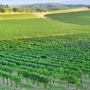
Precision Farming & Crop Planning
For most of human history, agricultural planning has primarily been a system of guesswork. Even with extensive data collected for a particular piece of land, variable factors remain unaccounted for, so we've used the best-fit approach. GIS removes much of the guesswork from crop planning and management by effectively collecting soil data and tracking seasonal patterns in line with changing conditions. This enables precision farming, enabling vineyard operations to maximize both yield and quality (3).
Soil Quality & Field Variability
Soil quality is never uniform, even within a single field. If the field slopes, drainage and water access can change drastically over just a few feet. Other factors affecting quality include sunlight exposure, shade patterns, rainfall distribution, and proximity to roads (which affects pollution levels, dust, and fragments of artificial materials like rubber and metal). All of these factors influence crop quality (4), and GIS enables farmers to map and respond to these variations.
Archaeological Features & Subsurface Analysis
Mapping technology has been used for years to find archaeological features in agricultural land, providing successful tools for the heritage industry (5). However, the same data types can be helpful for agricultural science, as underlying features can affect crop quality and relative height. Understanding bedrock composition and buried structures helps explain performance variations across fields.
Food Security & New Agricultural Areas
Identifying new areas to plant crops—whether to make existing yields more efficient or to provide increasing yields for our growing global population—represents the most significant ongoing challenge for agricultural science. GIS is currently being used as a crowdsourcing project to manage food security and reorganize crop production in developing regions (6), ensuring the maximum use of fragile soils in vulnerable areas.
Disaster Preparedness & Protection
GIS is essential for mapping areas vulnerable to natural disasters, such as drought and flooding, and for identifying food sources at risk. The World Food Program, the United Nations division concerned with food security, is one of the biggest users of GIS data for this purpose (7). They're involved in protecting food supplies by building civil engineering projects, such as dams, levees, and irrigation systems, to safeguard agricultural resources. Learn more about conservation and land management strategies that integrate GIS technology.
Modern GIS Tools & Technologies in Agriculture
Agricultural GIS has evolved dramatically since this field began gaining traction. Today's precision agriculture relies on technologies that didn't exist or weren't accessible to most farmers even a decade ago:
Drone Technology & Remote Sensing
Uncrewed aerial vehicles (UAVs) equipped with multispectral cameras now provide affordable, high-resolution crop monitoring that was previously available only through expensive satellite imagery. Farmers can identify stressed plants, irrigation issues, and pest damage before visible symptoms appear to the naked eye. These drone systems integrate directly with GIS platforms, enabling rapid data collection across large areas.
AI-Powered Analysis
Machine learning algorithms process GIS data to predict yields, recommend optimal planting dates, and identify early disease indicators. These systems learn from historical patterns to continuously improve accuracy. What once required weeks of manual analysis can now be completed in hours, with AI identifying spatial patterns humans might miss.
Mobile GIS Applications
Field technicians use tablet and smartphone GIS apps to collect real-time data, update maps on-site, and make immediate decisions without returning to office computers. This mobility has transformed how agricultural data is gathered and used, enabling responsive management throughout growing seasons.
IoT Sensor Integration
Soil moisture sensors, weather stations, and other Internet of Things (IoT) devices feed continuous data streams into GIS platforms, enabling automated irrigation systems and real-time crop management. This integration creates feedback loops where spatial analysis informs automated responses, optimizing resource use with minimal human intervention.
Career Opportunities & Salary in Agricultural GIS
Professionals combining GIS expertise with agricultural science knowledge are in growing demand as precision agriculture adoption accelerates. According to the US Bureau of Labor Statistics, environmental scientists (including agrarian GIS specialists) earn competitive salaries and have strong job growth projections.
Salary Data (May 2024 BLS):
- Median annual wage: $81,690
- Mean annual salary: $88,640
- Entry-level (10th percentile): $49,130
- Mid-career (25th percentile): $62,090
- Experienced professionals (75th percentile): $103,730
- Top earners (90th percentile): $134,830
Job Growth Outlook: The field is projected to grow 6% through 2032, adding approximately 4,800 new positions. With an average of 6,900 annual openings (including replacement positions), there are opportunities for well-prepared candidates entering the field. Explore additional environmental science career paths that utilize GIS technology.
Common Job Titles:
- Precision Agriculture Specialist
- Agricultural GIS Analyst
- Crop Consultant (GIS focus)
- Soil Scientist (GIS applications)
- Farm Management Advisor
- Land Use Planner (agriculture focus)
- Agricultural Remote Sensing Specialist
Employers: USDA and state agricultural departments, agricultural cooperatives, farming technology companies, environmental consulting firms, crop insurance providers, and agribusiness corporations all regularly hire professionals with combined GIS and agricultural expertise.
Educational Pathways
Building a career in agricultural GIS typically requires combining spatial analysis skills with knowledge of agricultural science. Here are the most common educational pathways:
| Educational Path | Primary Degree | GIS Component | Best For |
|---|---|---|---|
| Agriculture + GIS Minor | BS in Agricultural Science, Agronomy, or Crop Science | Minor in GIS or 4-6 GIS courses as electives | Students who are certain about an agricultural focus and want GIS as a specialized skill |
| GIS + Agriculture Minor | BS in Geographic Information Systems or Geography | Core degree with agriculture coursework | Students passionate about spatial analysis who wish to specialize in agricultural applications |
| Environmental Science (Both) | BS in Environmental Science | GIS courses + agricultural electives | Students wanting flexibility to explore both fields with a strong environmental focus |
| Graduate Specialization | Any relevant bachelor's degree | MS combining agricultural science + GIS focus | Career changers or those adding GIS skills to an existing agricultural background |
| Certificate Programs | Existing degree in agriculture or GIS | Post-baccalaureate certificate (6-12 months) | Working professionals adding complementary skills |
Most students we advise find success by pursuing an agricultural science degree as their major while taking GIS courses as a minor or elective concentration. This approach ensures strong agricultural foundations while building the spatial analysis skills that differentiate you in the job market. Explore GIS degree programs and certificate options to find pathways that match your interests.
Key Coursework to Prioritize:
- Introduction to GIS and spatial analysis
- Remote sensing and aerial imagery interpretation
- Soil science and agronomy
- Agricultural systems and crop management
- Statistics and data analysis
- Environmental science and conservation
Real-World Applications: Case Studies
Global Warming, Crop Production & GIS
We have a strong understanding of how our environment will change in the coming decades as weather patterns, soil acidity, deforestation, melting ice caps, and other effects of climate change affect our planet. We know how these changes might impact our food supply, even though the erratic nature of weather systems and climate patterns can only be fully measured as we continue to accumulate data and make adjustments. Food security represents one of the biggest threats to human civilization. This issue has always existed with natural disasters, but rarely with the permanent effects that require the coordinated global preparation we face today.
Increased erosion is another expected result of climate change that will undoubtedly impact crop production worldwide (8). Several complementary systems will be needed to build a comprehensive picture of crop production and to simulate yields, aiding future global planning. These systems will use the same data currently used by the UN for mapping potential disaster zones and plotting relief efforts (7).
Climate change is expected to affect crop production in several ways, including but not limited to (9):
- Precipitation changes affecting production (drought and flood cycles mentioned above)
- Temperature changes that may either shorten or lengthen growing seasons (potentially beneficial for crops like wine-producing grapes, but negative for most others)
Indirect effects include (9):
- Crop price fluctuations based on environmental changes could skew bulk pricing. Our food markets will change—not necessarily become unstable—but in some areas, core crops that are currently essential to local economies may become economically unviable.
- Alternatively, areas where growing certain crops was once economically nonviable may experience economic booms from new agricultural opportunities (12).
What was once marginal land for one crop may become viable for another, and vice versa. Economic instability may result. GIS will be fundamental in reorganizing what crops we grow and where, maximizing land efficiency as conditions shift.
Land Use Planning and GIS
Our growing population continues to seek new areas for settlement. Ideally, we prefer not to build new towns and cities on prime agricultural land. The problem is that land is one thing we aren't manufacturing. Land use presents challenges in the developed world, but in developing regions with significant marginal land, it becomes even more critical.
GIS is an essential tool in land planning worldwide (211 to. 211t211 to balance environmental demands and environmental capacity, because structure and funding don't exist to properly prepare for these factors in emerging economies—combined with a lack of historical geographic data—this has proven particularly problematic compared to developed nations where GIS use is far more common in planning developments (1, p13-14). Planning doesn't just apply to agricultural land (which has remained relatively static), but also to urban development (which has grown) and land being returned to natural use to preserve delicate ecologies (which has also increased in recent decades) (11, p155-6). Protected land is now a matter of public policy in most nations worldwide.
We need to understand not just soil quality, but also water quality. Crops need nutrients, and if soil and geology favor certain crops, we must ensure that the water supply and quality do too. Industrial activity nearby can contaminate food supplies through irrigation, with pollutants absorbed by crops (13). Agricultural scientists are interested not only in standing water but also in subsurface water supplies—the "water table" quality that affects irrigation over time.
Frequently Asked Questions
What is GIS in agriculture?
GIS (Geographic Information Systems) in agriculture refers to spatial mapping and analysis technology used to manage farmland, analyze soil variations, plan crop rotations, and predict yields. It combines GPS data, satellite imagery, and environmental measurements to help farmers and agricultural scientists make data-driven decisions about planting, irrigation, fertilization, and harvest timing.
What GIS software do agricultural scientists use?
Agricultural professionals commonly use ArcGIS (by ESRI) for comprehensive spatial analysis, QGIS for open-source solutions, and specialized platforms such as AgLeader, Climate FieldView, or the John Deere Operations Center. Many modern systems integrate drone imagery and IoT sensor data directly into GIS platforms for real-time field monitoring. The choice often depends on budget, specific applications, and integration needs with existing farm management systems.
Do I need a GIS degree to work in agricultural GIS?
Not necessarily. Many agricultural scientists add GIS skills through minors, certificates, or graduate coursework alongside their primary agrarian science degree. Some professionals enter the field with a GIS degree and then specialize in agricultural applications. Both pathways work—the key is combining spatial analysis expertise with agrarian knowledge. Many employers value practical experience with GIS tools as much as formal degrees.
What jobs use GIS in agriculture?
Common positions include precision agriculture specialists, crop consultants with a GIS focus, agricultural GIS analysts, soil scientists using spatial analysis, land-use planners specializing in agriculture, farm management advisors, and agricultural remote sensing specialists. Organizations like the USDA, agrarian cooperatives, farming technology companies, environmental consulting firms, crop insurance providers, and agribusiness corporations regularly hire these specialists.
How much do agricultural GIS specialists earn?
According to the Bureau of Labor Statistics (May 2024 data), environmental scientists, including agricultural GIS specialists, earn a median annual salary of $81,690 and a mean wage of $88,640. Entry-level positions start around $49,130, while experienced professionals earn $62,090 at the 25th percentile and $103,730 at the 75th percentile. Top earners in the field make over $134,830 annually. Salaries vary by experience, education, location, and employer type, with precision agriculture specialists in high-demand regions often earning above median wages.
Key Takeaways
- Emerging Career Opportunity: GIS technology is still gaining mainstream adoption in agricultural science, creating opportunities for early adopters with combined expertise in spatial analysis and agriculture. Professionals in this field earn competitive salaries, with median wages of 81,600, and strong 6% job growth is projected through 2032.
- Multiple Critical Applications: From precision farming and soil quality mapping to climate change adaptation and food security planning, GIS addresses critical agricultural challenges across scales—from optimizing individual fields to managing global food systems and disaster preparedness.
- Strategic Educational Path: Most successful professionals pursue agricultural science degrees while taking GIS as a minor or elective concentration. Since most programs don't yet integrate GIS as a core curriculum despite growing industry demand, students who proactively build these skills gain significant competitive advantages.
- Modern Technology Integration: Today's agricultural GIS combines drone imagery, AI-powered analysis, mobile applications, and IoT sensor networks. This technology evolution means professionals need skills in both traditional agricultural science and emerging spatial data technologies to remain competitive.
- Real-World Impact Potential: GIS applications extend beyond individual farm profitability to address global challenges such as climate change adaptation, food security in vulnerable regions, and sustainable land-use planning. Professionals in this field contribute to critical environmental and humanitarian efforts while building rewarding careers.
Ready to combine GIS technology with agricultural science expertise? Explore degree programs that offer GIS coursework alongside agricultural studies and position yourself at the forefront of precision agriculture and sustainable food systems.
Related Degrees:
Sources:
- US Bureau of Labor Statistics – Occupational Employment and Wage Statistics, May 2024. Environmental Scientists and Specialists, Including Health (SOC 19-2041)
- US Bureau of Labor Statistics – Employment Projections, 2022-2032
- Longley, P.A., Goodchild, M.F., Maguire, D.J. & Rhind, D.W. 2011: Geographic Information Systems & Science (Third Edition). Wiley: Hoboken, New Jersey
- ESRI – Agricultural GIS solutions and precision farming applications
- USDA Natural Resources Conservation Service (NRCS) – Soil mapping and GIS integration
- UN World Food Programme – Food security monitoring and disaster preparedness mapping
- NASA Applied Sciences – Remote sensing and drone technology in agriculture
- Nature – AI and machine learning applications in plant science and yield prediction
- GIS Lounge: Use of GIS in Agriculture
- ESRI: World-Class Vineyard Uses GIS
- Computerworld: CGIAR and Agricultural Research
- ESRI: GIS Supports World Food Programme
- ScienceDirect: GIS in Agricultural Applications
- ResearchGate: Remote Sensing and GIS for Land Use Planning
- VU Amsterdam: Land Use Scanner
- Natural England: GIS in Environmental Management
2024 US Bureau of Labor Statistics salary and job growth figures for Environmental Scientists and Specialists reflect national data, not school-specific information. Conditions in your area may vary. Data accessed January 2026. View current BLS data.
- What Is Parasitology? The Science of Parasites Explained - November 19, 2018
- Desert Ecosystems: Types, Ecology, and Global Importance - November 19, 2018
- Conservation: History and Future - September 14, 2018
Related Articles


Featured Article
The Future of Agriculture: Biotechnology and GM Crops