Surveyors collect precise spatial measurements in the field using GPS receivers and total stations, while cartographers and photogrammetrists analyze survey data, satellite imagery, and GIS information to create maps and spatial visualizations. The Bureau of Labor Statistics tracks these as separate occupations: surveyors (SOC 17-1022) and cartographers/photogrammetrists combined (SOC 17-1021). Surveyors typically need a high school diploma plus apprenticeship training, earning a median salary of $68,540 annually. Cartographers require a bachelor's degree in GIS or geography, earning $76,210 annually. Employment is projected to grow 4-6% through 2034, creating approximately 4,900 annual job openings combined (including both new positions and replacements for retiring workers).
Surveyors and cartographers form a complementary partnership in spatial data science, transforming how we understand and navigate our physical world. From ancient Mesopotamian land boundary surveys using measuring ropes to today's LiDAR-equipped drones mapping infrastructure projects with millimeter precision, these professions have evolved dramatically while maintaining their core mission: accurately representing Earth's surface. The Bureau of Labor Statistics combines cartographers and photogrammetrists (specialists in aerial and satellite imagery analysis) into a single occupational category, though their day-to-day work differs significantly from traditional map production.
The division of labor is clear but interdependent: surveyors serve as field data collectors, establishing control points and capturing spatial measurements through direct observation and instrumentation. Cartographers function as spatial analysts and visual communicators, processing survey data alongside satellite imagery, demographic information, and environmental datasets to produce maps that serve specific analytical or navigational purposes. Understanding which role aligns with your interests—field-intensive data collection or office-based spatial analysis—is the first step in choosing your career path.
Consider these questions as you evaluate these career options: Do you prefer collecting data outdoors or analyzing it in a climate-controlled office? Are you comfortable with physical exertion in variable weather, or does the prospect of working with GIS software and data visualization appeal more strongly? Your answers will guide whether surveying, cartography, or a hybrid role in modern geospatial technology best fits your interests and capabilities.
What Does a Surveyor/Cartographer Do?
The Surveyor's Role
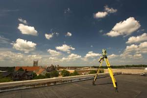
Surveyors establish precise horizontal and vertical positions of natural and human-made features on Earth's surface. They begin projects by researching historical survey records, property deeds, and land titles to understand existing boundaries and control points. In the field, surveyors operate sophisticated measurement equipment, including GPS receivers accurate to centimeters, total stations that combine electronic distance measurement with angle measurement, and levels for determining elevation differences. Modern surveyors increasingly deploy drone-based photogrammetry systems and terrestrial LiDAR (Light Detection and Ranging) scanners that capture millions of data points per second, particularly for large infrastructure projects or environmental monitoring applications.
The work requires meticulous attention to detail—a surveyor's measurements often serve as the foundation for multimillion-dollar construction projects, legal property disputes, or infrastructure planning decisions. Surveyors establish benchmarks and control networks that subsequent projects reference for years or decades. They prepare detailed field notes, sketches, and data logs that document their measurement procedures, ensuring other professionals can understand and validate their work. Many surveyors spend significant time preparing legal descriptions of property boundaries, creating subdivision plats, and providing expert testimony in boundary dispute cases.
The Cartographer's Role
Cartographers transform raw spatial data into visual representations that communicate geographic information effectively. Working primarily with Geographic Information Systems (GIS) software platforms like ArcGIS, QGIS, and specialized mapping tools, cartographers integrate data from multiple sources: survey measurements, satellite imagery, demographic databases, environmental sensors, and historical records. This integration requires extensive data validation—checking for survey errors, resolving conflicting data sources, ensuring spatial accuracy, and maintaining appropriate coordinate system transformations.
The cartographer's work combines technical spatial analysis with visual design principles. They select appropriate map projections for the geographic area and intended use, choose symbolization that enhances readability without oversimplifying complex data, and apply cartographic conventions that help users interpret the map correctly. Modern cartographers increasingly create interactive digital maps and web-based GIS applications rather than static paper products. They work extensively with remote sensing data, interpreting multispectral satellite imagery to identify land cover types, monitor environmental changes, or track urban development patterns. To understand the full history and evolution of mapmaking from ancient clay tablets to modern digital platforms, cartography has progressed through numerous technological revolutions while maintaining core principles of spatial accuracy and visual clarity.
How These Roles Work Together
The surveyor-cartographer partnership creates a complete workflow from field data collection to final map production. Surveyors provide the precise control points and measurements that anchor maps to real-world coordinates. Cartographers contextualize these measurements by adding layers of information—topography, infrastructure, political boundaries, demographic patterns—that transform coordinate data into actionable geographic intelligence. In many organizations, particularly government agencies and large engineering firms, professionals move fluidly between roles or specialize in one while maintaining a deep understanding of both disciplines.
Work Environment and Physical Demands
Typical Work Settings
Employment patterns differ dramatically between the two occupations, reflecting their distinct work environments. According to May 2024 Bureau of Labor Statistics data, 68% of the nation's 53,080 surveyors work for private architectural and engineering services firms, with another 9% in construction, 8% in government agencies, and 4% self-employed as independent consultants. Cartographers and photogrammetrists show the opposite distribution: 41% of the 12,790 professionals work in local government agencies, 18% in architectural and engineering services, and notably, 4% for the federal government, where median wages reach $106,950—substantially higher than the occupation median.
Surveyors split their time between office preparation and extensive fieldwork. Office time involves researching property records, processing field data using specialized software, preparing legal descriptions and plats, and coordinating with clients and project stakeholders. Fieldwork takes surveyors to construction sites, rural properties, highway corridors, and sometimes remote wilderness areas requiring overnight travel. They work near active construction equipment, alongside busy roadways (wearing reflective safety gear), through wetlands and forests, and occasionally in underground mines or tunnels for specialized surveying projects.
Physical Requirements for Surveyors
Let's be clear about the physical demands of surveying: this is not primarily a desk job. Surveyors walk several miles daily across uneven terrain, carrying equipment cases and tripods weighing 20-40 pounds. They stand for extended periods while operating instruments, often on slopes or in unstable footing conditions. The work happens in all weather conditions—summer heat exceeding 100�F, winter cold below freezing, rain, snow, and high winds. Surveyors encounter poison ivy, ticks, mosquitoes, and occasionally hazardous wildlife. Projects near highways require constant awareness of traffic hazards. Good physical fitness, outdoor tolerance, and situational awareness are essential rather than optional for surveying careers.
Cartographers work in dramatically different conditions. Most spend their entire workday in climate-controlled office environments, seated at computer workstations running GIS software and design applications. Physical demands are minimal—primarily sustained computer use with associated ergonomic considerations like proper desk setup and regular breaks to prevent repetitive strain. Some cartographers conduct occasional fieldwork to verify topographic features or ground-truth satellite imagery classifications, but this represents a small fraction of their work time. The office-centric nature of cartography makes it accessible to individuals who prefer or require indoor work environments.
Remote Work Opportunities
The COVID-19 pandemic accelerated a trend that continues reshaping cartography: widespread adoption of remote work. Many cartography positions now offer hybrid or fully remote options, particularly in private sector GIS roles, consulting firms, and software companies developing mapping applications. Cartographers primarily use desktop software and cloud-based platforms that function identically from home or the office. However, positions in government agencies requiring access to classified or sensitive data typically mandate on-site work for security reasons.
Surveying remains inherently field-intensive and cannot transition to remote work. While surveyors can process field data and prepare deliverables from home offices, the core measurement and data collection activities require physical presence at project sites. This fundamental difference in remote work feasibility represents a significant career consideration in the post-2020 work landscape.
Surveyor and Cartographer Salary and Compensation
Compensation differs notably between surveyors and cartographers, with cartographers earning higher median wages reflecting their typically more extensive educational requirements and specialized technical skills. The Bureau of Labor Statistics tracks these occupations under separate codes following recent reclassification: surveyors under SOC 17-1022 and cartographers and photogrammetrists under SOC 17-1021. Note that employment figures vary between BLS data sources: the Occupational Employment and Wage Statistics (OEWS) survey reports 53,080 surveyors and 12,790 cartographers as of May 2024, while Employment Projections (EP) uses a 2024 base year of 56,100 surveyors and 13,400 cartographers. This difference reflects different survey methodologies and timing—we use OEWS figures when discussing current wages and EP figures when discussing growth projections.
The following table presents May 2024 wage data from the Occupational Employment and Wage Statistics (OEWS) survey, showing the full salary range from entry-level positions through senior professionals:
| Percentile | Surveyors (SOC 17-1022) | Cartographers/Photogrammetrists (SOC 17-1021) |
|---|---|---|
| 10th Percentile | $41,430 | $48,660 |
| 25th Percentile | $50,970 | $60,430 |
| Median (50th) | $68,540 | $76,210 |
| 75th Percentile | $91,520 | $95,610 |
| 90th Percentile | $109,660 | $113,540 |
| Mean (Average) | $76,730 | $82,860 |
| Total Employment | 53,080 | 12,790 |
The wage gap between the 10th and 90th percentiles exceeds $64,000 for both occupations, reflecting the significant premium paid to experienced professionals with advanced skills and licensure. Cartographers earn approximately $7,670 more at the median than surveyors, likely reflecting the specialized technical expertise in GIS analysis, remote sensing interpretation, and spatial data science that bachelor's degree programs develop.
Certain industries offer substantially higher compensation than these national medians. The oil and gas extraction sector leads with mean annual wages of $107,240 for cartographers, followed by environmental remediation services ($105,740) and natural gas distribution ($96,920). For surveyors, specialized surveying fields, including mining operations, offer median wages of around $86,050—approximately 25% above the occupation median. Federal government positions for cartographers pay a median of $106,950, making government service an attractive option for those willing to work on-site with potentially classified or sensitive geospatial data.
Job Outlook and Growth Projections
Employment Trends Through 2034
The Bureau of Labor Statistics projects steady employment growth for both occupations through 2034, with cartographers and photogrammetrists growing slightly faster than surveyors. The Employment Projections (EP) program uses a 2024 base year of 56,100 surveyors (slightly higher than the 53,080 reported in the May 2024 OEWS wage survey due to different methodologies), projected to reach 58,600 by 2034—an increase of 2,500 positions representing 4% growth, about average for all occupations. Cartographers and photogrammetrists start from a base of 13,400 in 2024, projected to reach 14,300 by 2034—adding 900 positions for 6% growth, faster than the average for all occupations.
These projections translate to approximately 3,900 annual job openings for surveyors and 1,000 for cartographers and photogrammetrists. These openings come from a combination of employment growth and the need to replace workers who retire or permanently leave the occupation. The aging workforce in surveying creates substantial replacement demand, as many licensed surveyors approach retirement age and few young professionals enter the field to replace them.
Multiple factors drive continued demand for surveying and cartography services. Infrastructure investment initiatives at the federal, state, and local levels require extensive surveying for highway reconstruction, bridge replacement, water system upgrades, and public facility construction. Climate change adaptation efforts—coastal resilience planning, flood risk mapping, wildfire mitigation—depend heavily on current, accurate geospatial data. The proliferation of Geographic Information Systems across industries, from urban planning to precision agriculture to public health, creates a growing demand for professionals who can collect, analyze, and visualize spatial data. Natural disaster response and recovery efforts require the rapid deployment of surveyors and cartographers to assess damage, plan reconstruction, and update infrastructure maps.
Industries Hiring
Surveyors find the largest number of opportunities in private architectural and engineering services firms that provide surveying services to developers, construction companies, and government agencies. Construction firms increasingly maintain in-house surveying capabilities for large projects. State and local government agencies—particularly transportation departments, planning departments, and public works agencies—employ surveyors for highway projects, subdivision reviews, and infrastructure maintenance. The energy sector offers specialized opportunities in pipeline surveying, oil and gas facility layout, and renewable energy site assessment.
Cartographers concentrate in different sectors. Local government agencies—particularly planning departments, GIS offices, and emergency management agencies—employ the largest share of cartographers. Federal agencies, including the U.S. Geological Survey, National Oceanic and Atmospheric Administration, Department of Defense, and Census Bureau, maintain substantial cartographic and GIS staffs. Private sector opportunities exist with software companies developing mapping applications, consulting firms providing GIS services, environmental consulting firms requiring spatial analysis capabilities, and increasingly, technology companies operating digital mapping services like Google Maps, Apple Maps, and specialized navigation platforms.
Another high-demand specialization is hydrographic surveying for coastal and marine mapping, particularly relevant given increased focus on coastal infrastructure, offshore wind energy projects, port development, and navigation safety. Hydrographic surveyors use specialized multibeam sonar systems and marine LiDAR equipment, often working from survey vessels in coastal and offshore environments.
Education and Training Requirements
Surveyor Education Pathways
Surveying offers multiple entry pathways depending on your career goals and timeline. Entry-level surveying positions—typically titled survey technician or survey assistant—require only a high school diploma. These positions involve assisting licensed surveyors in the field, operating equipment under supervision, maintaining equipment, and performing basic calculations. Many surveyors enter the profession through this apprenticeship route, gaining practical skills while earning income.
However, professional advancement in surveying requires licensure in all 50 states and the District of Columbia, and most states require a four-year bachelor's degree for licensure eligibility. The most direct path involves earning a bachelor's degree in surveying, geomatics, or geomatics engineering from a program accredited by the Applied and Natural Science Accreditation Commission of ABET. These programs combine classroom instruction in mathematics, physics, surveying principles, legal aspects of surveying, and GPS technology with extensive hands-on field training. Alternatively, civil engineering degrees with a surveying concentration or geography degrees with a geomatics emphasis can qualify for licensure in most states.
Coursework typically includes trigonometry and calculus, legal principles of real property and boundaries, GPS and satellite positioning systems, photogrammetry and remote sensing, geographic information systems, survey computations and adjustments, construction surveying, route surveying for highways and utilities, and land development and subdivision design. Many programs require summer field camps where students spend several weeks conducting intensive survey projects in varied terrain.
Cartographer Degree Requirements
Cartography positions typically require a bachelor's degree as the minimum qualification, with Geographic Information Systems (GIS) emerging as the most common major. Geography departments at most universities now offer GIS concentrations or standalone GIS degrees that prepare students for cartography careers. These programs combine traditional cartographic principles with modern spatial analysis techniques, programming skills, and remote sensing interpretation. Some cartographers enter the field with degrees in geography (with strong GIS coursework), environmental science (with GIS emphasis), urban planning, or related fields that incorporate substantial geospatial technology training.
Essential coursework includes cartographic design principles, GIS software applications (ArcGIS, QGIS), programming for spatial analysis (Python, R), remote sensing and image interpretation, spatial statistics and geostatistics, web mapping and application development, database design for spatial data, and map projection theory. Many programs require capstone projects where students complete real-world mapping projects for community organizations or research initiatives.
Photogrammetry specialists—who extract measurements and create maps from aerial and satellite imagery—often pursue additional specialized training or graduate degrees in photogrammetry, remote sensing, or geospatial science. The growth of drone technology has created demand for photogrammetrists skilled in processing imagery from small unmanned aerial systems.
Licensing and Certification
All 50 states and the District of Columbia require surveyors to be licensed before they can certify boundary surveys, create legal property descriptions, or sign survey plats. This licensure requirement protects the public by ensuring only qualified professionals perform work with significant legal and financial consequences. The licensing pathway involves passing two examinations administered by the National Council of Examiners for Engineering and Surveying (NCEES).
The first examination, the Fundamentals of Surveying (FS) exam, consists of 110 multiple-choice questions administered over a 6-hour appointment. The exam fee is $225 paid to NCEES. Designed for recent graduates, it covers mathematics, surveying measurements and technology, surveying computations, and legal principles. The pass rate for first-time takers approximates 66%. Passing the FS exam earns the designation "Surveyor Intern" or "Land Surveyor in Training" in most states.
After accumulating four years of progressive experience working under a licensed professional surveyor's supervision, candidates become eligible for the Principles and Practice of Surveying (PS) exam. This 100-question exam, administered over a 7-hour appointment, tests advanced surveying knowledge, including boundary law, surveying standards, and professional responsibility. The pass rate for first-time takers approximates 70%. Successfully passing the PS exam leads to Professional Surveyor (PS) or Professional Land Surveyor (PLS) licensure, depending on state terminology. The NCEES Records Program facilitates license reciprocity, allowing licensed surveyors to apply for credentials in additional states through their maintained records.
Cartographers and most photogrammetrists are not required to hold state licenses, though some states require photogrammetrists to be licensed when their work involves property boundaries or creates documents with legal standing. Instead, cartographers pursue voluntary professional certifications that demonstrate competency and commitment to the field.
The GIS Professional (GISP) certification from the GIS Certification Institute represents the primary credential for GIS specialists and cartographers. Obtaining GISP certification requires four years of professional GIS experience, accumulating at least 30 points each in educational achievement and professional experience categories, a minimum of 8 points in professional contributions (publications, presentations, committee service), and passing the GISCI Geospatial Core Technical Knowledge Exam. The application fee is $100, the examination fee is $250, and the annual maintenance costs are $95. Approximately 6,500 professionals worldwide maintain active GISP status, providing a recognized credential that signals advanced competency in an unlicensed field.
The National Society of Professional Surveyors administers the Certified Survey Technician (CST) program with four progressive certification levels. Level I requires no specific experience and covers basic field operations and equipment. Level II requires 1.5 years of experience and demonstrates intermediate competencies. Level III requires 3.5 years and establishes advanced technical skills. Level IV requires 5.5 years plus Level III certification and demonstrates supervisory capabilities. The U.S. Department of Labor recognizes CST within its National Apprenticeship Program, making it valuable for surveyors building their pre-licensure experience.
Cartography - Related Degrees
Essential Skills and Qualifications
Technical Skills
Both surveyors and cartographers require strong mathematical foundations. Surveyors use trigonometry constantly for angle and distance calculations, apply coordinate geometry for establishing control networks, and employ least squares adjustment techniques to process redundant measurements and minimize errors. Cartographers utilize statistics for spatial analysis, understand map projection mathematics, and increasingly apply machine learning algorithms for automated feature extraction from imagery. Spatial reasoning—the ability to visualize three-dimensional objects and relationships from two-dimensional representations—is essential for both professions.
Precision and attention to detail cannot be overstated. Surveying errors of inches can translate to property boundary disputes affecting hundreds of thousands of dollars in real estate value. Cartographic errors—incorrect feature placement, inappropriate projection selection, misleading symbolization—can lead to flawed decision-making by map users. Both professions demand systematic checking procedures, thorough documentation, and the discipline to maintain accuracy even under time pressure or challenging field conditions.
Software Proficiency
Surveyors work extensively with field data collection software from major manufacturers, including Trimble, Leica Geosystems, and Topcon. These systems run on rugged handheld controllers connected to GPS receivers, total stations, and digital levels. Surveyors process field data using specialized survey adjustment software and Computer-Aided Design (CAD) programs—particularly AutoCAD Civil 3D and Carlson Survey—to create boundary plats, topographic maps, and construction layout plans. Knowledge of coordinate systems, datum transformations, and projection parameters is essential for ensuring survey data integrates correctly with other geographic information.
Cartographers must master GIS platforms, including Esri's ArcGIS Pro (the industry standard), QGIS (the leading open-source alternative), and increasingly, web mapping libraries like Mapbox, Leaflet, and ArcGIS JavaScript API for creating interactive online maps. Graphic design proficiency using Adobe Illustrator and Photoshop allows cartographers to create publication-quality maps with sophisticated visual design. Programming skills—particularly Python for spatial analysis automation and R for statistical mapping—are increasingly valuable. Database knowledge (SQL, PostgreSQL with PostGIS extension) enables cartographers to manage and query large spatial datasets efficiently.
Physical Capabilities
Surveying requires good physical fitness and outdoor tolerance. Surveyors must be capable of walking several miles daily across uneven terrain, standing for extended periods on slopes, lifting and carrying equipment weighing 40+ pounds, working in extreme temperatures from below freezing to over 100�F, tolerating exposure to sun, insects, and weather, and maintaining balance and stability in challenging terrain. Color vision is important for distinguishing colored markers and equipment displays. Individuals with physical limitations that prevent extensive outdoor work or heavy lifting may find cartography's office-based environment more accommodating.
Soft Skills for Success
Communication skills prove essential in both professions. Surveyors interact with property owners during boundary surveys, coordinate with construction crews on job sites, explain technical findings to clients who lack surveying knowledge, and occasionally provide expert testimony in legal proceedings. Cartographers present spatial analysis results to decision-makers, collaborate with stakeholders to understand mapping requirements, document methods and data sources in metadata, and often train others in using GIS tools and interpreting maps.
Problem-solving abilities separate adequate practitioners from excellent ones. Surveyors encounter ambiguous historical evidence, conflicting property descriptions, and challenging terrain requiring creative measurement approaches. Cartographers reconcile conflicting data sources, devise appropriate ways to visualize complex multidimensional datasets, and troubleshoot technical issues in GIS workflows. Both professions reward systematic thinking, logical reasoning, and persistence when facing difficult technical challenges.
Teamwork is inherent to surveying—field crews typically include a licensed surveyor directing one or more assistants—and increasingly important in cartography as GIS projects grow larger and more complex. Time management and organizational skills help professionals balance multiple concurrent projects, meet deadlines, and maintain thorough documentation of their work.
Modern Tools and Technology
The surveying and mapping professions have undergone a revolutionary technological transformation over the past three decades. Traditional tools—theodolites for angle measurement, steel tapes and EDM (electronic distance measurement) devices for distances, levels for elevations—persist in some applications but have largely given way to integrated systems combining multiple measurement technologies.
Global Navigation Satellite Systems (GNSS), including GPS, GLONASS, Galileo, and BeiDou, now provide the foundation for most surveying work. Real-Time Kinematic (RTK) GPS systems achieve centimeter-level accuracy by using corrections transmitted from base stations, allowing surveyors to establish control points and measure features with precision that would have required hours of conventional instrument work. Total stations—electronic theodolites with integrated distance measurement and data recording—remain essential for situations where GNSS signals are obstructed or when measuring angles and distances directly from occupied stations.
Unmanned Aerial Systems (drones or UAVs) have revolutionized data collection for mapping projects. Survey-grade drones equipped with high-resolution cameras capture overlapping imagery that photogrammetry software processes into detailed orthophotos (geometrically corrected aerial photographs), digital elevation models, and three-dimensional models. This technology allows rapid mapping of large areas—work that previously required expensive manned aircraft flights or extensive ground surveys. Drones prove particularly valuable for construction progress monitoring, volumetric calculations for mining and earthwork, and mapping hazardous or inaccessible areas.
Terrestrial LiDAR (Light Detection and Ranging) scanners emit millions of laser pulses per second, measuring distances to create incredibly dense three-dimensional point clouds of structures and landscapes. Mobile LiDAR systems mounted on vehicles scan roadways and corridors at highway speeds. Airborne LiDAR systems penetrate vegetation canopies to measure ground elevations beneath forests. These technologies generate unprecedented detail—surveyors and cartographers can measure features that would be impractical or impossible to survey using conventional instruments.
On the cartography side, cloud-based GIS platforms like ArcGIS Online and CARTO enable browser-based mapping without requiring desktop software installation. Web mapping APIs allow developers to embed interactive maps in websites and applications. Artificial intelligence and machine learning algorithms increasingly automate feature extraction from satellite imagery—identifying buildings, roads, water bodies, and vegetation types that cartographers previously digitized manually. These technologies don't eliminate the need for skilled cartographers but shift their work toward higher-level analysis, quality control, and custom application development.
Career Advancement and Specializations
Entry to Senior Progression
Surveyors typically begin as survey technicians or survey assistants, working under supervision to operate equipment, collect field data, perform calculations, and learn professional standards. After accumulating experience and passing the FS exam, they advance to survey party chief or crew chief positions, leading field teams and taking greater responsibility for project quality. Obtaining the professional surveyor license after passing the PS exam opens senior surveyor positions where professionals sign and seal survey plats, take legal responsibility for boundary determinations, and manage complex projects. The career path continues to project manager positions overseeing multiple concurrent surveys, managing client relationships, and supervising junior staff, and ultimately to principal or partner roles in surveying firms or chief surveyor positions in government agencies.
Cartographers begin as GIS technicians or junior cartographers, performing routine tasks like digitizing features, geocoding addresses, updating existing maps, and maintaining spatial databases. With experience and demonstrated technical proficiency, they advance to GIS analyst or cartographer positions with greater autonomy in project design, responsibility for complex spatial analyses, and opportunities to develop custom tools and applications. Senior cartographer or GIS specialist positions involve project leadership, technical mentorship of junior staff, and often specialization in particular application areas like environmental analysis, urban planning, or public health. Career progression continues to GIS manager or chief cartographer roles with responsibility for the entire GIS operations, strategic technology planning, and coordination across multiple departments or agencies.
Specialized Fields
Surveying offers numerous specializations beyond the general boundary and construction surveying. Geodetic surveyors use highly precise techniques, including satellite observations and laser-based measurements, to establish control networks covering large geographic areas, contributing to national spatial reference systems and monitoring crustal movement. Hydrographic surveyors focus on coastal and marine environments, using multibeam sonar systems to map seafloors for navigation charts, dredging projects, and offshore construction. Mining surveyors work in underground environments, measuring ore bodies and ensuring safe excavation operations while earning some of the profession's highest wages. Forensic surveyors specialize in accident reconstruction and expert witness testimony. Cadastral surveyors work on public lands, particularly with the Bureau of Land Management, establishing the Public Land Survey System that subdivides much of the United States.
Cartography specializations increasingly center on application domains and technical capabilities. Environmental cartographers develop maps supporting conservation planning, species habitat modeling, and environmental impact assessment. Urban planning cartographers create zoning maps, growth projection visualizations, and demographic mapping for municipal planning departments. Public health GIS specialists map disease patterns, analyze health disparities, and support epidemiological investigations. Cartographers increasingly specialize in particular technologies: remote sensing specialists interpret satellite and aerial imagery, web cartographers build interactive mapping applications, LiDAR specialists process point cloud data, or spatial database administrators design and maintain enterprise geospatial data systems.
Leadership Opportunities
Experienced surveyors and cartographers transition into various leadership roles. Some establish independent consulting practices, particularly licensed surveyors who can build firms providing surveying services to developers, attorneys, and government agencies. Academia offers opportunities for those with advanced degrees—teaching surveying or GIS courses, conducting geospatial research, and training the next generation of professionals. Government leadership positions include county surveyor (an elected position in some states), state surveyor, director of GIS operations for state or local agencies, or senior positions in federal mapping agencies. Private sector leadership includes a director of geospatial services for engineering firms, a chief technology officer for GIS software companies, or a mapping operations manager for technology companies operating navigation services.
Day-to-Day Responsibilities
Typical Surveyor Tasks
A surveyor's day begins with project preparation—reviewing client requirements, researching historical survey records and property deeds, planning the surveying approach, and organizing necessary equipment. Field days start early to avoid intense afternoon heat in summer or maximize daylight hours in winter. The survey crew travels to the project site, often navigating rough access roads to reach remote properties. They unload equipment, establish a base station for GPS corrections if using RTK positioning, and begin systematic measurement of property corners, topographic features, or construction layout points as the project requires.
Fieldwork involves constant movement—walking between measurement points, clearing brush or obstacles from sight lines, setting and recovering survey markers, and maintaining careful documentation of all measurements and observations. Surveyors photograph monuments, sketch unusual boundary conditions, note evidence of occupation like fences or structures, and record conversations with property owners about boundary locations. They check measurements for consistency, reobserve questionable positions, and maintain equipment calibration throughout the day. Physical challenges include carrying equipment through dense vegetation, working on steep slopes, tolerating extreme weather, and remaining alert to hazards like traffic, unstable ground, or aggressive animals.
After fieldwork concludes, surveyors return to the office to download field data, process GPS observations or total station measurements, adjust traverse networks to minimize accumulated errors, and prepare deliverables. They draft boundary plats showing property dimensions and monuments, create topographic maps with contour lines and feature symbols, prepare written legal descriptions of surveyed boundaries, and compile thorough documentation of their methods and findings. Licensed surveyors review and sign technical documents, accepting professional responsibility for the accuracy and completeness of the surveying work.
Typical Cartographer Tasks
Cartographers spend most days working at computers, beginning by receiving or reviewing project requirements from clients or supervisors. They gather necessary data sources—existing GIS layers, survey data, satellite imagery, demographic databases, and environmental monitoring data—and assess data quality, coverage, and compatibility. Significant time goes to data preprocessing: converting coordinate systems, correcting geometric errors, filtering noise from elevation data, classifying land cover types from multispectral imagery, or geocoding address lists to create mappable point locations.
The core cartographic work involves spatial analysis and map design. Cartographers perform queries to select relevant features, run geoprocessing operations like buffering or overlay analysis, calculate statistics like density or proximity, and generate derived products like slope maps or viewshed analyses. They make countless design decisions: selecting appropriate map projections, choosing color schemes that enhance readability while remaining accessible to colorblind users, determining which features to emphasize and which to generalize or omit, placing labels to maximize readability without obscuring features, and applying cartographic conventions that help users interpret the map correctly.
Modern cartographers increasingly work with web technologies, writing code in JavaScript to create interactive maps, configuring map services for online access, designing responsive layouts that work on desktop and mobile devices, and testing applications across different browsers and screen sizes. They document their methods in technical metadata, prepare user guides explaining how to interpret maps and use interactive features, and often conduct training sessions teaching colleagues or clients to use GIS tools and understand spatial analysis results.
Senior-Level Responsibilities
Senior surveyors and cartographers take on project management responsibilities beyond technical execution. They scope projects by estimating required time and resources, prepare proposals and cost estimates for potential clients, negotiate contracts and project terms, and develop project schedules balancing multiple concurrent deadlines. They serve as primary client contacts, conducting progress meetings, responding to questions and concerns, and managing scope changes or unforeseen complications that arise during project execution.
Technical leadership involves mentoring junior staff, reviewing their work for quality and accuracy, providing guidance on solving complex technical problems, and helping them develop professional judgment. Senior professionals often specialize in particularly difficult project types—complex boundary disputes, large infrastructure projects, or sophisticated spatial analyses—where their expertise and experience prove essential. They maintain awareness of new technologies and methods, evaluating whether adoption would benefit their organization and leading implementation of new tools or procedures. Many participate in professional societies, contribute to technical publications, and attend conferences to stay current with evolving best practices in their fields.
Professional Organizations and Resources
National Society of Professional Surveyors (NSPS)
The National Society of Professional Surveyors serves as the unified voice for surveying professionals across the United States, representing the interests of approximately 10,000 members. NSPS provides valuable benefits, including continuing education programs that help licensed surveyors meet state requirements for license renewal, advocacy for professional licensing standards and surveying regulations at state and federal levels, networking opportunities through state chapter meetings and the annual NSPS conference, access to technical publications covering surveying methods and legal issues, and professional development resources, including the Certified Survey Technician program. NSPS works closely with NCEES on surveying examination development and with state licensing boards on professional standards.
North American Cartographic Information Society (NACIS)
The North American Cartographic Information Society connects professionals working in cartography, GIS, and geospatial information across government, academia, and private industry. NACIS emphasizes innovation in mapmaking and spatial visualization, hosting annual conferences where cartographers share new techniques and technologies, publishing the peer-reviewed journal Cartography and Geographic Information Science, maintaining active discussion forums for technical problem-solving, and organizing student competitions that encourage the next generation of cartographers. The society welcomes practitioners from various backgrounds, including traditional cartographers, GIS analysts, web mapping developers, and anyone interested in the art and science of mapmaking.
The Imaging and Geospatial Information Society (ASPRS)
The American Society for Photogrammetry and Remote Sensing (ASPRS) specializes in the science of obtaining reliable information about physical objects and the environment through processes of recording, measuring, and interpreting imagery and digital representations. ASPRS provides essential resources for photogrammetrists, remote sensing specialists, and LiDAR professionals, including technical publications on photogrammetric methods and remote sensing applications, professional certifications (Certified Photogrammetrist, Certified Mapping Scientist) that demonstrate advanced competency, continuing education through webinars and workshops on emerging technologies, and networking opportunities at regional and national conferences. The society plays a leading role in establishing technical standards for accuracy and quality in photogrammetric mapping and remote sensing projects.
GIS Certification Institute
The GIS Certification Institute administers the GIS Professional (GISP) credential, the primary professional certification for GIS specialists and cartographers. GISCI maintains the certification standards, develops and administers the Geospatial Core Technical Knowledge Exam, reviews certification applications to verify experience and educational requirements, and oversees the continuing education requirements that maintain active GISP status. Beyond certification, GISCI promotes professionalism in the GIS community, maintains a registry of certified professionals that employers can search when recruiting, and provides resources on GIS career development and professional ethics. The GISP credential carries recognition globally, with certified professionals working in 59 countries.
Frequently Asked Questions
What's the main difference between a surveyor and a cartographer?
Surveyors work outdoors collecting spatial measurements using equipment like GPS receivers and total stations. They establish property boundaries, create topographic surveys, and provide precise coordinate data for construction projects. Cartographers work indoors processing survey data, satellite imagery, and GIS information to create maps and spatial visualizations. Think of surveyors as data collectors and cartographers as data analysts and visual designers. The work environments differ dramatically—surveyors face physical demands and outdoor conditions while cartographers work in climate-controlled offices using computers.
Do I need a college degree to become a surveyor?
Entry-level surveying positions typically require only a high school diploma and on-the-job training as a survey technician. However, most states require a four-year bachelor's degree in surveying, geomatics, or a related field for professional licensure. Since all 50 states mandate licensure before surveyors can sign boundary surveys or create legal property descriptions, career advancement strongly favors degree holders. The licensing process also requires passing two rigorous examinations and accumulating four years of supervised experience under a licensed professional surveyor. If you're serious about a surveying career, plan on earning a bachelor's degree to maximize your opportunities and earning potential.
Can cartographers work remotely?
Yes, many cartography positions now offer remote or hybrid work options, particularly in private sector GIS roles, consulting firms, and software companies developing mapping applications. Cartographers primarily use desktop software and cloud-based platforms that function identically from home or office locations. However, government agency positions requiring access to classified or sensitive data typically mandate on-site presence for security reasons. Some cartographers conduct occasional fieldwork to verify topographic features or ground-truth satellite classifications, but this represents a small fraction of work time. The remote work flexibility in cartography contrasts sharply with surveying, which remains field-intensive and cannot transition to remote work arrangements.
What software do surveyors and cartographers use?
Surveyors use field data collection software from major manufacturers, including Trimble, Leica Geosystems, and Topcon, running on rugged handheld controllers connected to GPS receivers and total stations. They process survey data using Computer-Aided Design programs, particularly AutoCAD Civil 3D and Carlson Survey, to create boundary plats and construction plans. Cartographers work extensively with GIS platform,s including Esri's ArcGIS Pro (the industry standard) and QGIS (leading open-source alternative). They use graphic design tools like Adobe Illustrator and Photoshop for map production, web mapping libraries like Mapbox and Leaflet for interactive online maps, and increasingly rely on programming languages like Python and R for spatial analysis automation. Database skills in SQL and PostgreSQL help cartographers manage large spatial datasets efficiently.
Is surveying physically demanding?
Yes, surveying involves significant physical activity. Surveyors walk several miles daily carrying equipment weighing 20-40 pounds, work outdoors in all weather conditions from below freezing to over 100�F, navigate rough terrain including steep slopes and dense vegetation, stand for extended periods while operating instruments, and tolerate exposure to sun, heat, cold, insects, and occasionally hazardous conditions near construction sites or traffic. The work requires good physical fitness and outdoor tolerance. Individuals preferring or requiring less physical work find cartography's office-based environment more suitable, though some cartographers conduct occasional fieldwork for data verification purposes.
Key Takeaways
- Complementary Career Paths: Surveyors focus on fieldwork and data collection using hands-on measuring equipment in outdoor environments, while cartographers concentrate on data analysis and map production using GIS software in office settings. This fundamental distinction allows you to choose based on your preference for outdoor physical work versus indoor analytical work.
- Competitive Compensation: Cartographers and photogrammetrists earned a median salary of $76,210 in 2024, while surveyors earned $68,540 median annually. The top 10% in both occupations earned over $109,000, with federal government positions and the oil/gas extraction sector offering premium compensation exceeding the $106,000 median wages.
- Accessible Entry for Surveyors: Unlike many technical careers requiring bachelor's degrees for entry, surveying allows you to start with a high school diploma and apprenticeship training. However, professional licensure—mandatory in all 50 states for signing boundary surveys—requires a bachelor's degree, four years of supervised experience, and passing two rigorous examinations administered by NCEES.
- Growing Field with Strong Prospects: The Bureau of Labor Statistics projects 4% employment growth for surveyors through 2034 (adding 2,500 jobs) and 6% growth for cartographers (adding 900 jobs), faster than average for all occupations. Combined, these fields will create approximately 4,900 annual job openings through both employment growth and the replacement of retiring professionals.
- Technology Evolution Creating Opportunities: The profession has transformed from manual theodolites and measuring chains to GPS systems accurate to centimeters, LiDAR scanners capturing millions of data points per second, and drones revolutionizing aerial mapping. This evolution makes surveying and cartography ideal careers for those interested in working with cutting-edge spatial technology while maintaining a connection to traditional measurement principles and the fundamental human need to understand and navigate our physical world.
Ready to begin your career in spatial data science? Explore surveying and cartography degree programs that align with your interests in field-based data collection or office-based spatial analysis and visualization.

2024 US Bureau of Labor Statistics salary and employment figures for surveyors, cartographers, and photogrammetrists reflect national data, not school-specific information. Conditions in your area may vary. Data accessed January 2026.